According to the World Heritage Convention, “Cultural heritage” is a monument, group of buildings or site of historical, aesthetic, archaeological, scientific, ethnological or anthropological value…” (UNESCO 2003).
Saho land in Eritrea is believed to have one of the highest densities of archaeological sites known to African continent. Most of all known Eritrean archaeological sites are located in Saho region; as such, this region could be considered a birth place from which ancient Eritrean history and identity has evolved.
Ancient rock paintings, monuments steles, ruined building, ancient pottery found in Saho region are some of the testaments to the richness and diversity of this particular region.
Adulis or Adu – Lai
The old Eritrean port known as Adulis is about 60 kilometres south of Massawa. It lies between the villages Zola and Afta, in the proximity of the larger locality Fodo. The original name for Adulis in Saho is probably “Adu Lai” meaning “white water” or ” Ado – La” meaning white herd, later recorded as Adulis by Ptolemaic and Azuli by Arab traders who frequented the port. However, the name Ado-Lai, have more resonance, since there is another village in the hinterland still called Adu-Lai.
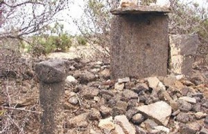
No serious excavation has yet been made. However, Adulis is believed to be the oldest civilization site in Eritrea . Some Experts believes it was first settled in the mid -3 rd – sixth century BC. It was a major trade route between the interiors of pre-Aksumite, Aksumite Kingdom & other civilizations in the region, i.e. Egypt , Arabia (Sabaa), Persia & Indian subcontinent.
Egypt is the source of the earliest descriptions of the people that resided in the areas that is Eritrea and Ethiopia today. This area was known to the Egyptians as Punt. As early as the third millennium BCE, the Egyptian inscriptions indicate that they traded with people from the land of Punt , who they sometimes they also called “Gods’ Land”.
Land of Punt and Ado-Lai
Egyptians did sail south along the Red Sea to trade with people from Punt. Punt, to the Egyptians, could have meant the entire Red Sea region including Somalia. But artefacts found in Egypt indicate that Adulis has played a key role in trade with old Egypt. For Egyptians land of Punt was a commercial centre, from which they were able to import incense, ivory, ebony and gum.
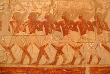
They also imported the skins of giraffes, panthers and cheetahs that were worn by temple priests, and sometimes even live animals were imported. Because of the goods from Punt used by priests to adorn garden of the god, Amun. A stele in the mortuary temple of Amonhotep III (18 th Dynasty) records a speech delivered by
the god Amun, stating: “Turning my face to sunrise I created a wonder for you, I made the lands of Punt come here to you, with all the fragrant flowers of their lands, to beg your peace and breath the air you give.”
The earliest recorded sailing expedition to land of Punt was taken by King
Saho Ra’a Fifth Dynasty (2465 -2325 BCE). But some experts believe trade with the two peoples could have started “as early as the First Dynasty (3100-2890 BCE). The Puntites themselves also sailed to Egypt and their products.
Although the actual location of land of Punt is still contested, according to some experts Eritrea has as good claim if not a better claim, as any of those nations who claim to be the Land of Punt . Fauna and flora ecologically coincide with northern Eritrea/Ethiopia and east-north-east Sudan . This identification is supported by later references to the rain on the Mountains of Punt draining into the Nile flood which thus excludes an identification of Punt in Somalia as has sometimes been suggested. It is believed Egypt-Punt trade “link ended after the mid” 12 th century BC. Why is yet unknown.
Qohaito:
“The site of Qohaito, positioned on top of the Qohaito plateau at an elevation of approximately 2,600m, contains many large mounds, elaborate monumental architecture, cistern-like features, and a large ancient dam and reservoir basin”. ( Anfray 1981: Danielli and Marinelli 1912; Litman et al. 1913; Wenig 1997).
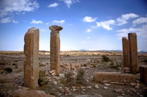
“Qohaito appears to have been a garden city, with cultivated areas between the building complexes. There are dozens of these ruined complexes varying greatly in structure, size and depth; only further survey will reveal precisely the configurations and numbers of these futures on this landscape. There are also half a dozen column structures or temples on platform dispersed widely”. (Berhe, Haile, The preservation of the cultural heritage of Eritrea , 9-15/October/ 2000).
Qohaito in Saho meaning “Rock” is one of the oldest and significant civilization site in Eritrea today. It is one of five Eritrean sites nominated for the UNESCO World Heritage List.
This ancient urban city lies approx. 14-15 Kilometres southeast of Asa Dik (Adi Keih). Its position at the crossroads of the main communication axes between the Red Sea area in the in the North-East and mainland of Kaskase, Matara and Axum in the South made it one of the most political centres of the Kingdom of ancient Eritrea.
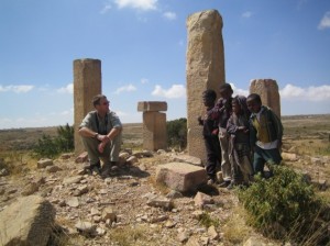
The city’s impressive large remains- cover an area of 2.5Km by 15 Km; so far only 20% of the ruins have been excavated. To the north the sandstone-hewn known locally as Egyptian Tomb can be detected (see image). So named not because its Egyptian origin has
been conclusively proven but because of the tomb’s impressive dimensions. Inside the tomb carved on walls and facing each other are flower shaped symbol perhaps indicating some sort of religious or social significance of the person who was buried there.
Another historical feature which can be seen in Qouhaito today is the beautifully dressed masonry of Saphira Dam. (See image left).
The dam is over 60m long and is believed to date
back 1000 years. The wall of the dam is built of large rectangular blocks of stones; the largest measures 98cm * 48cm. Although there are indications of several other dams existed, only this dam still serves the local population as the main source of water.
Near Qohaito are several rock-art sites , including Awalu Galba rock shelter on the Awalu Guda plateau of Hainaba. The rock shelters measures approximately three meters in depth and 12 meters in length. On the walls of the shelter elaborate pictographs in red, white and black pigments can be observed. A number of pictographs have been destroyed by natural exfoliation and by chipping of images from the wall by the people. Cattle and possible human-like figures are depicted on rock shelter’s walls.
Kaskase
Kaskase located about 4 kilometres to the north of Senafe was one of the key city civilizations in pre-Aksumite period. However, none of the grandeur or glory of its past can be detected today. According to oral history
passed by older generation in Senafe, Kaskase was indeed, very important place. According to this history, it was ruled by a queen. Unfortunately, neither name of the queen or other details is remembered. However, artefacts found in Kaskase area and currently stored in national museum in Asmara , seem to corroborate the importance and the glorious past off Kaskase. Items recovered from the vicinity include; statues and several inscriptions which resembles South Arabian (Sabaean).
This small Sabaean – style sphinx from the 5 th-6 th century BCE was discovered in Kaskase region and currently sits in national museum in Asmara .

The inscriptions on this Kaskase piece reads right to left on the first line and left to right on the second. Linguists state that many ancient languages used this writing method, called boustrophedon (plow-like), at various periods of the development of their written language.
Was Kaskase a local kingdom known by archaeologists as Kingdom of Damat or was it part of extended Sabaean Kingdom ?. Unfortunately, the answer to this question has to wait a while, since there is no enough evidence and no enough study has yet been conducted to unravel the past mystery of Kaskase.
Sanafè/ Senafe
The ancient name for Sanafe is Hakir. The name of the town was changed after a tribe migrated from Yemen settled at the foothills
of a local mountain now known as Ain Senafe. The tribe is still known as Senafe; hence the name of the tribe was given to the town. According to local history when the immigrants reached the northern peak of the mountain, they asked locals by saying Sanaa fen? Where is Sanaa (their home town?). The dormant volcanic rock where this conversation took place is still known as “Arab Tarika”, from the Arabic word “Arab Tarakna” perhaps indicating they had left Arabia.

Senafe is also home to famous archaeological ruins of Balaw Kalaw. They are also known by nearby village called Matara. The ruins at Matara site are considered to be the third largest pre-Aksumite or Aksumite historical site.
A western visitor who saw Senafe described it as a scene from wonder land. That is because the city seats on very pleasant plains and is encircled by most striking mountains. Arab Tarika from North, Dorho
Coma from east, Farkila and Saim Coma from South, Matara Coma from South West and Ain Senafe from West are key features of the town.

Balaw Kalaw:
The plan of the ruined city and its beautiful foundation walls (see image left) in some of the palace complexes indicated it is was abode to a sizeable bourgeois or middle-class community. Some of scattered ruins are believed to have been established around the fifth century BC.
The 4.68meter long stele found in Matara is unique in the whole of Eritrea . The sun over the crescent moon curved at the top of the stele is the symbol of Sabaean supreme God known as Almaqah (moon God).
As the god of Saba he was official god of the state.”Almaqah” deity who was obviously worshipped by people of Senafe as well, is the destroyer, the god of heavy rains, storm and flood.
At the bottom of the stele non vocalised proto-Ghe’eze inscription is translated to “King Agheze dedicates this monument to his fore-fathers who have defeated the mighty people of Awe’alefene and Wetsebelan”?

Sadly, now this beautiful monument lies shattered on the ground (see image left) as another victim of the war, after it was vandalised by advancing Ethiopian army following 1998 war between the two countries.
Massawa : The idda tribe of Saho are believed to be the original inhabitants of the city now known as Massawa. Saho name for Massawa is Mandar meaning city. The town of Dakano (meaning elephant) now known as Harkiko is believed to be where the city has started its life.
